Originaldatei(SVG-Datei, Utgangsgrött: 200 × 236 Pixel, Dateigrött: 157 KB)


Wikimedia Commons Logo Disse Datei warrt direkt vun Wikimedia Commons inbunnen.

Angaven to'n Autor un de Lizenz staht op de Sied to de Datei bi Commons.

Beschrieven

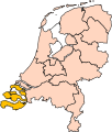
Beschrievung Location of the province of Zeeland in the Netherlands.
Datum/Tiet
Born Own work, based on freely available GIS data
Autor User:Mtcv
Lizenz/Verlööv
(Disse Datei annerwegens bruken)
Data: attribution required; my work: PD
Annere Versionen I attempted to make an svg version of Image:Zeeland-Position.png (with less simplified boundaries)

Clickable version

South HollandNorth HollandFrieslandGroningenDrentheFlevolandOverijsselGelderlandUtrechtLimburgNorth BrabantZeeland

Lizenz

© Der Urheberrechtsinhaber dieser Datei, Centraal Bureau voor de Statistiek, erlaubt es jedem, diese für jeden Zweck zu benutzen, vorausgesetzt, dass der Urheberrechtsinhaber ordnungsgemäß genannt wird. Weiterverbreitung, Abänderungen, kommerzielle Nutzung sowie jede andere Verwendung sind gestattet.

VRT Wikimedia

Verlööv, disse Datei to bruken, is över dat the Wikimedia-VRT-System bestätigt un archiveert worrn.
Dat Verlööv kann vun Lüüd mit en VRTS-Konto ankeken warrn. Wenn du keen Konto hest un dat Verlööv bestätigt hebben wullt, denn fraag een vun de Lüüd mit en VRTS-Konto oder schriev op Commons:Volunteer Response Team/Noticeboard.

Lenk na dat Ticket: https://ticket.wikimedia.org/otrs/index.pl?Action=AgentTicketZoom&TicketNumber=2007041210008226
Find other files from the same ticket: SDC query (SPARQL)

This image is (in part or entirely) based on geographical data from Statistics Netherlands (Centraal Bureau voor de Statistiek). Digital geometry files in ESRI format can be downloaded from their website [1].

In particular, boundary data of statistical districts is based on either the Wijk- en buurtkaart 2005, or the Wijk- en buurtkaart 2003 ("CBS/TOPgrenzen"). Data on localities (bevolkingskernen) are from the publication Bevolkingskernen in Nederland 2001.

Conditions of use (in Dutch):

  • Bij visualisering van gegevens met behulp van het digitale bestand Wijk- en buurtkaart 2005 dient te worden vermeld:
Bron: © 2006, Centraal Bureau voor de Statistiek / Topografische Dienst Kadaster
  • Bij visualisering van gegevens met behulp van het digitale bestand CBS/TOPgrenzen dient te worden vermeld:
Grenzen ondergrond: © 2003, Centraal Bureau voor de Statistiek/Topografische Dienst Kadaster
  • Bij visualisering van gegevens met behulp van het digitale bestand "Bevolkingskernen 2001" dient te worden vermeld:
Bron: © 2005, Centraal Bureau voor de Statistiek

Unless otherwise specified, data on waterways and lakes are from the public domain Digital Chart of the World.

Bildnotizen
InfoField
Diese Datei ist annotiert: Betrachte diese auf Commons.

Kurzbeschreibungen

Ergänze eine einzeilige Erklärung, was diese Datei darstellt.

In dieser Datei abgebildete Objekte

wiest

Datei-Historie

Klick op de Tiet, dat du de Datei ankieken kannst, so as se do utseeg.

Datum/TietDuumnagelbildGröttBrukerKommentoor
aktuell19:21, 2. Mär 2019Duumnagelbild för Version vun’n 19:21, 2. Mär 2019200 × 236 (157 KB)Thaytsupdate
02:49, 3. Okt. 2006Duumnagelbild för Version vun’n 02:49, 3. Okt. 2006200 × 236 (158 KB)Mtcv{{Information| |Description=Location of the province of Noord-Holland (North Holland) in the Netherlands. |Source=Own work, based on freely available GIS data |Date=2006-10-03 |Author=User:Mtcv |Permission=Data: attribution required; my work: PD |othe

Disse Sied bruukt dit Bild:

Allmeen Datei-Bruuk

Metadaten