Bild:Brazil Municipalities.png

Grött vun disse Vörschuu: 676 × 600 Pixels. Anner Oplösungen: 271 × 240 Pixels | 541 × 480 Pixels | 866 × 768 Pixels | 1.155 × 1.024 Pixels | 1.627 × 1.443 Pixels.
Originaldatei (1.627 × 1.443 Pixel, Grött: 207 KB, MIME-Typ: image/png)
| Disse Datei warrt direkt vun Wikimedia Commons inbunnen. Angaven to'n Autor un de Lizenz staht op de Sied to de Datei bi Commons. |

|
Dat gifft nu ok en Vektorversion vun dit Bild (SVG).
Wenn dat SVG-Bild nich slechter is, denn schull dat man lever bruukt warrn. File:Brazil Municipalities.png → File:Brazil Municipalities.svg
För mehr Infos över Vektorgrafiken, lees Commons transition to SVG. Dat gifft dor ok Infos över, wo MediaWiki SVGs ünnerstütten deit. |
 |
| Beschrievung |
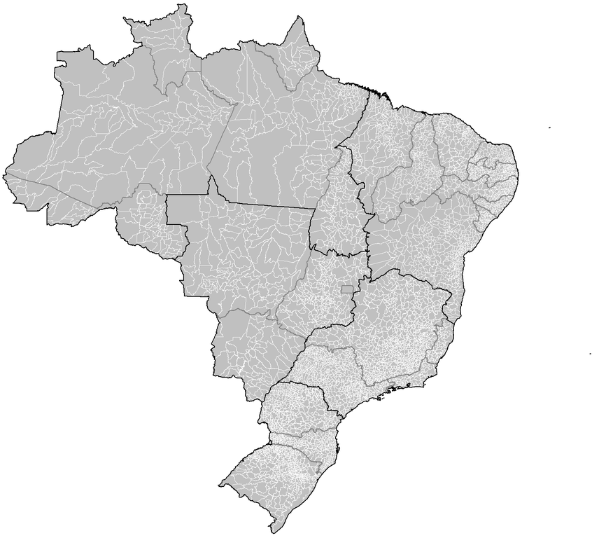
Português: Map of the municipalities of Brazil. |
||
| Datum/Tiet | |||
| Born | Created using MapInfo Professional v8.5 and various mapping resources. | ||
| Autor | Rarelibra | ||
| Lizenz/Verlööv (Disse Datei annerwegens bruken) |
|
||
| Annere Versionen | Von disse Datei afleidt Warken: Brazil Metropolitan Regions.png |
Datei-Historie
Klick op de Tiet, dat du de Datei ankieken kannst, so as se do utseeg.
| Datum/Tiet | Duumnagelbild | Grött | Bruker | Kommentoor | |
|---|---|---|---|---|---|
| aktuell | 06:18, 18. Mär 2020 | | 1.627 × 1.443 (207 KB) | ContaDeletada1993 | Brazilian Federal Dis cannot be divided into municipalities. |
| 04:08, 28. Nov. 2019 |  | 1.627 × 1.443 (215 KB) | Allice Hunter | Those divisions weren't municipalities. | |
| 09:05, 26. Jul. 2018 |  | 1.627 × 1.443 (207 KB) | Morta Linda | Update. Distrito Federal cannot be divided into municipalities. According to the Brazilian Constitution, the Federal District assumes the same constitutional and legal powers, attributions and obligations of the states and municipalities. Instead, it is divided by 31 administrative regions that do not have the same function as municipalities. | |
| 20:53, 23. Jan. 2008 |  | 1.627 × 1.443 (215 KB) | Rarelibra | updated map | |
| 05:10, 3. Dez. 2006 |  | 1.281 × 880 (76 KB) | Felipe Menegaz | == Summary == Map of the municipalities of Brazil. Created by Rarelibra 18:34, 24 August 2006 (UTC) for public domain use. Created using MapInfo Professional v8.5 and various mapping resources. == Licensing == {{PD-self}} |
Dateibruuk
Disse Sied bruukt dit Bild:
Allmeen Datei-Bruuk
Disse annern Wikis bruukt disse Datei:
- Bruuk op ar.wikipedia.org
- Bruuk op ban.wikipedia.org
- Bruuk op bpy.wikipedia.org
- Bruuk op br.wikipedia.org
- Bruuk op ca.wikipedia.org
- Bruuk op da.wikipedia.org
- Bruuk op en.wikipedia.org
- Bruuk op eo.wikipedia.org
- Bruuk op es.wikipedia.org
- Bruuk op fr.wikipedia.org
- Bruuk op hu.wikipedia.org
- Bruuk op id.wikipedia.org
- Bruuk op it.wikipedia.org
- Bruuk op ka.wikipedia.org
- Bruuk op mk.wikipedia.org
- Bruuk op pt.wikipedia.org
- Bruuk op pt.wikisource.org
- Bruuk op ro.wikipedia.org
- Bruuk op ru.wikipedia.org
- Bruuk op sco.wikipedia.org
- Bruuk op sq.wikipedia.org
- Bruuk op tr.wikipedia.org
- Bruuk op uk.wikipedia.org
- Bruuk op ur.wikipedia.org
- Bruuk op zh-min-nan.wikipedia.org
- Bruuk op zh.wikipedia.org