Bild:Kuunga2.jpg

Grött vun disse Vörschuu: 764 × 600 Pixels. Anner Oplösungen: 306 × 240 Pixels | 612 × 480 Pixels | 1.000 × 785 Pixels.
Originaldatei (1.000 × 785 Pixel, Grött: 215 KB, MIME-Typ: image/jpeg)
| Disse Datei warrt direkt vun Wikimedia Commons inbunnen. Angaven to'n Autor un de Lizenz staht op de Sied to de Datei bi Commons. |
Beschrieven

|
Vun disse Datei gifft dat nu en betere Utgaav File:Kuunga2.png. Wi raadt an, disse annere Datei to bruken.
|

|
| Beschrievung |
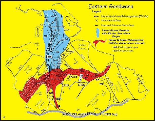
English: Paleotectonic map of eastern Gondwana with the Pan-African and/or circum-Antarctic orogenic (“mobile”) belts highlighted by age differences (See Fitzsimons, 2000a, cited in Meert, 2003, see source data below). Meaning of abbreviations: Af = Afif terrane (Saudi Arabia); AFB = Albany-Fraser Belt (Australia); AS = Angavo shear zone (Madagascar); BH = Bunger Hills (Antarctica); BR = Bongolava-Ranotsara shear zone (Madagascar); BS = Betsimisaraka suture zone (Madagascar); DB = Damara Belt (Africa); DDS = Darling-Denman suture (Antarctica - Australia); DG = Denman Glacier (Antarctica); DMS = Dronning Maud suture (Antarctica); EG = Eastern Ghats (India); GB = Gariep Belt (Africa); HC = Highland Complex (Sri Lanka); LA = Lufilian Arc (Africa); LG = Lambert Graben (Antarctica); LHB = Lützow-Holm Belt (Antarctica); MD = Mwembeshi Dislocation (Africa); MP = Maud Province (Antarctica); NBS = Nabitah Suture (Arabia); nPCSM = Northern Prince Charles Mountains (Antarctica); NQ = Namaqua Belt (Africa); OSH = Onib-Sol Hamed suture (Arabia); PBB = Prydz Bay Belt (Antarctica); PC = Paughat-Cauvery (India); SB = Saldania Belt (Africa); SR = Shackelton Range (Antarctica) ; UAA = Urd Al Amar suture (Arabia); VC = Vijayan Complex (Sri Lanka); WC = Wanni Complex (Sri Lanka); WI = Windmill Islands (Antarctica); ZB = Zambezi Belt (Africa). |
| Datum/Tiet | 6. März 2006 (Datum, as de Datei toeerst hooglaadt worrn is) |
| Born |
Adapted from fig 2 in: Joseph G. Meert (2003): A synopsis of events related to the assembly of eastern Gondwana. Tectonophysics 362(1–4; Special Issue Paleomagnetism Applied to Tectonics. A tribute to Rob Van der Voo.):1–40, doi:10.1016/S0040-1951(02)00629-7 (manuscript available at UFL). The editor is the author of the above paper and has modified the figure included in the paper. Originally uploaded to the English Wikipedia by Jmeert. |
| Autor | Jmeert |
| Lizenz/Verlööv (Disse Datei annerwegens bruken) |
Released into the public domain (by the author). |
Lizenz
| |
Dit Bild is vun sien Autor, Jmeert, wikipedia, as gemeenfree freegeven worrn. Dat gellt op de ganze Welt. Wenn so’n Freegaav vun dat Gesett her nich mööglich is: |
Ursprüngliches Datei-Logbuch
The original description page was here. All following user names refer to en.wikipedia.
- 2006-03-06 14:15 Jmeert 1000×785×8 (220296 bytes) http://www.clas.ufl.edu/users/jmeert/kuunga.jpg adapted from: Meert, J.G., A synopsis of events related to the assembly of eastern Gondwana, Tectonophysics, 362, 1-40 The editor is the author of the above paper and has modified the figure included in t
Datei-Historie
Klick op de Tiet, dat du de Datei ankieken kannst, so as se do utseeg.
| Datum/Tiet | Duumnagelbild | Grött | Bruker | Kommentoor | |
|---|---|---|---|---|---|
| aktuell | 12:16, 29. Feb. 2008 | | 1.000 × 785 (215 KB) | File Upload Bot (Magnus Manske) | {{BotMoveToCommons|en.wikipedia}} {{Information |Description={{en|http://www.clas.ufl.edu/users/jmeert/kuunga.jpg adapted from: Meert, J.G., A synopsis of events related to the assembly of eastern Gondwana, Tectonophysics, 362, 1-40 The editor is the |
Dateibruuk
Kene Siet bruukt dat Bild.