Bild:LocationCentralAfricanEmpire.png
Gifft dat Bild nich grötter.
LocationCentralAfricanEmpire.png (250 × 115 Pixel, Grött: 6 KB, MIME-Typ: image/png)
| Disse Datei warrt direkt vun Wikimedia Commons inbunnen. Angaven to'n Autor un de Lizenz staht op de Sied to de Datei bi Commons. |

|
Dat gifft nu ok en Vektorversion vun dit Bild (SVG).
Wenn dat SVG-Bild nich slechter is, denn schull dat man lever bruukt warrn. File:LocationCentralAfricanEmpire.png → File:Central African Empire in its region.svg
För mehr Infos över Vektorgrafiken, lees Commons transition to SVG. Dat gifft dor ok Infos över, wo MediaWiki SVGs ünnerstütten deit. |
 |
Beschrieven
| Beschrievung |
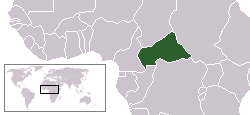
English: Locator map of the former Central African Empire — an autocratic monarchy the existed from 1976 to 1979.
|
| Datum/Tiet | 27. Juli 2007 (Datum, as de Datei toeerst hooglaadt worrn is) |
| Born | Die Autorenschaft wurde nicht in einer maschinell lesbaren Form angegeben. Es wird angenommen, dass es sich um ein eigenes Werk handelt (basierend auf den Rechteinhaber-Angaben). |
| Autor | Die Autorenschaft wurde nicht in einer maschinell lesbaren Form angegeben. Es wird Hoshie als Autor angenommen (basierend auf den Rechteinhaber-Angaben). |
Lizenz
| Disse Datei is vun sien Autor, I, Hoshie, as gemeenfree freegeven worrn. Dat gellt op de ganze Welt. Wenn dat na lokale Rechtslaag nich mööglich is, gellt: I, Hoshie gewährt jedem das bedingungslose Recht, dieses Werk für jedweden Zweck zu nutzen, es sei denn, Bedingungen sind gesetzlich erforderlich. |
Datei-Historie
Klick op de Tiet, dat du de Datei ankieken kannst, so as se do utseeg.
| Datum/Tiet | Duumnagelbild | Grött | Bruker | Kommentoor | |
|---|---|---|---|---|---|
| aktuell | 07:47, 27. Jul. 2007 | | 250 × 115 (6 KB) | Hoshie | This is a map of the Central African Empire. This map is virtually the same as User:Vardion's location map of the Central African Republic with only two changes. Eritrea and |
Dateibruuk
Kene Siet bruukt dat Bild.