Bild:Map of Kentucky highlighting Lincoln County.svg

Größe der PNG-Vorschau dieser SVG-Datei: 800 × 345 Pixels. Anner Oplösungen: 320 × 138 Pixels | 640 × 276 Pixels | 1.024 × 441 Pixels | 1.280 × 551 Pixels | 2.560 × 1.103 Pixels | 6.770 × 2.916 Pixels.
Originaldatei (SVG-Datei, Utgangsgrött: 6.770 × 2.916 Pixel, Dateigrött: 127 KB)
| Disse Datei warrt direkt vun Wikimedia Commons inbunnen. Angaven to'n Autor un de Lizenz staht op de Sied to de Datei bi Commons. |
Beschrieven
| Beschrievung |
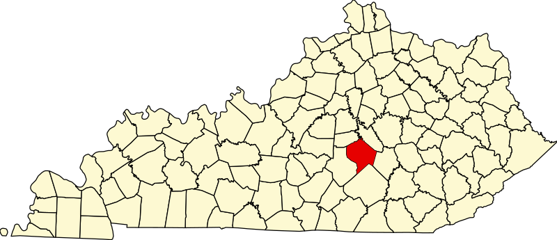
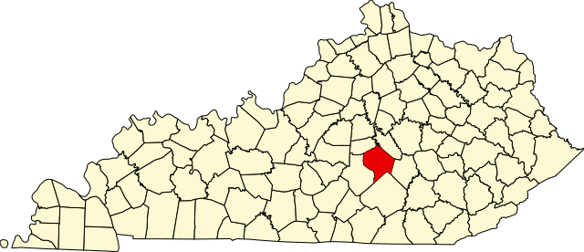
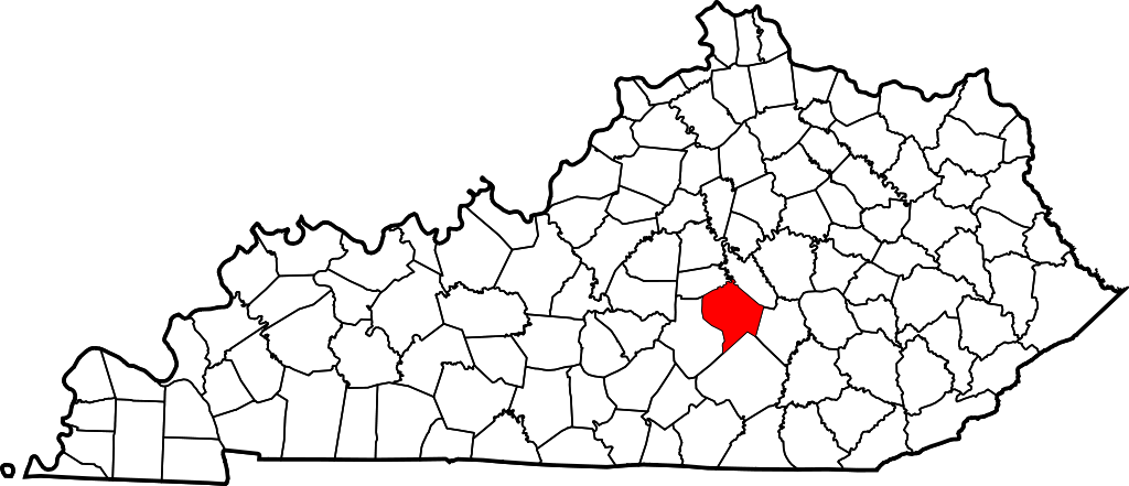
English: This is a locator map showing Lincoln County in Kentucky. For more information, see Commons:United States county locator maps. |
| Datum/Tiet | |
| Born |
Egen Wark: English: The maps use data from nationalatlas.gov, specifically countyp020.tar.gz on the Raw Data Download page. The maps also use state outline data from statesp020.tar.gz. The Florida maps use hydrogm020.tar.gz to display Lake Okeechobee. |
| Autor | David Benbennick |
Lizenz
| Ich, der Urheberrechtsinhaber dieses Werkes, veröffentliche es als gemeinfrei. Dies gilt weltweit. Wenn dat na lokale Rechtslaag nich mööglich is, gellt: Ich gewähre jedem das bedingungslose Recht, dieses Werk für jedweden Zweck zu nutzen, es sei denn, Bedingungen sind gesetzlich erforderlich. |
Datei-Historie
Klick op de Tiet, dat du de Datei ankieken kannst, so as se do utseeg.
| Datum/Tiet | Duumnagelbild | Grött | Bruker | Kommentoor | |
|---|---|---|---|---|---|
| aktuell | 14:23, 12. Feb. 2006 | | 6.770 × 2.916 (127 KB) | David Benbennick | {{subst:User:Dbenbenn/clm|county=Lincoln County|state=Kentucky}} |
Dateibruuk
Disse Sied bruukt dit Bild:
Allmeen Datei-Bruuk
Disse annern Wikis bruukt disse Datei:
- Bruuk op ar.wikipedia.org
- Bruuk op bg.wikipedia.org
- Bruuk op bpy.wikipedia.org
- Bruuk op ca.wikipedia.org
- Bruuk op cdo.wikipedia.org
- Bruuk op ceb.wikipedia.org
- Bruuk op ce.wikipedia.org
- Bruuk op cs.wikipedia.org
- Bruuk op cy.wikipedia.org
- Bruuk op de.wikipedia.org
- Bruuk op en.wikipedia.org
- Lincoln County, Kentucky
- Crab Orchard, Kentucky
- Hustonville, Kentucky
- Stanford, Kentucky
- Junction City, Kentucky
- Eubank, Kentucky
- Cedar Creek (Dix River tributary)
- List of counties in Kentucky
- Template:Lincoln County, Kentucky
- User:Nyttend/County templates/KY/2
- National Register of Historic Places listings in Lincoln County, Kentucky
- Category:Populated places in Lincoln County, Kentucky
- O K, Kentucky
- Dog Walk, Kentucky
- Chicken Bristle, Kentucky
- Blue Lick, Kentucky
- Turkeytown, Kentucky
- Jumbo, Kentucky
- Hubble, Kentucky
- Walnut Flat, Kentucky
- Preachersville, Kentucky
- Pleasant Point, Lincoln County, Kentucky
- Miracle, Lincoln County, Kentucky
- Kings Mountain, Kentucky
- Waynesburg, Kentucky
Kiek na mehr almeen Bruuk von disse Datei.