Bild:Race to the Sea 1914.png

Grött vun disse Vörschuu: 493 × 600 Pixels. Anner Oplösungen: 197 × 240 Pixels | 395 × 480 Pixels | 740 × 900 Pixels.
Originaldatei (740 × 900 Pixel, Grött: 71 KB, MIME-Typ: image/png)
| Disse Datei warrt direkt vun Wikimedia Commons inbunnen. Angaven to'n Autor un de Lizenz staht op de Sied to de Datei bi Commons. |
| Beschrievung |
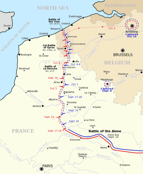
Map showing the course of the "Race to the Sea" during 1914 following the Battle of the Aisne. Allied front line and movement is shown in red, German front line and movement shown in blue. Three of the battles that occurred during or after the "race" are shown boxed. Based on a map from A Short Military History of World War I - Atlas, edited by T. Dodson Stamps and Vincent J. Esposito, 1950. |
| Datum/Tiet | |
| Born | Gsl Originally uploaded to EN Wikipedia 8 August 2004 |
| Autor | Gsl |
| Disse Datei is vun sien Autor, Gsl op de Wikipedia op Engelsch, as gemeenfree freegeven worrn. Dat gellt op de ganze Welt. Wenn dat na lokale Rechtslaag nich mööglich is, gellt: Gsl gewährt jedem das bedingungslose Recht, dieses Werk für jedweden Zweck zu nutzen, es sei denn, Bedingungen sind gesetzlich erforderlich. |
Datei-Historie
Klick op de Tiet, dat du de Datei ankieken kannst, so as se do utseeg.
| Datum/Tiet | Duumnagelbild | Grött | Bruker | Kommentoor | |
|---|---|---|---|---|---|
| aktuell | 20:18, 5. Jan. 2014 | | 740 × 900 (71 KB) | Hohum | Fix minor mistake |
| 20:16, 5. Jan. 2014 |  | 740 × 900 (71 KB) | Hohum | More map-like | |
| 07:59, 5. Nov. 2007 |  | 740 × 900 (72 KB) | Rcbutcher | {{Information |Description=Map showing the course of the "Race to the Sea" during 1914 following the Battle of the Aisne. Allied front line and movement is shown in red, German front line and movement shown in blue. Three of |
Dateibruuk
Disse Sied bruukt dit Bild:
Allmeen Datei-Bruuk
Disse annern Wikis bruukt disse Datei:
- Bruuk op ar.wikipedia.org
- Bruuk op azb.wikipedia.org
- Bruuk op be-tarask.wikipedia.org
- Bruuk op be.wikipedia.org
- Bruuk op ca.wikipedia.org
- Bruuk op de.wikipedia.org
- Bruuk op en.wikipedia.org
- Douglas Haig, 1st Earl Haig
- British Expeditionary Force (World War I)
- 63rd (Royal Naval) Division
- First Battle of the Aisne
- Battle of Albert (1914)
- 1st Royal Naval Brigade
- Draft:Douglas Haig in 1914-15
- First Battle of Picardy
- Wikipedia:WikiProject Military history/News/November 2014/World War I timeline
- Wikipedia:WikiProject Military history/News/November 2014/Op-ed
- Bruuk op es.wikipedia.org
- Bruuk op eu.wikipedia.org
- Bruuk op fi.wikipedia.org
- Bruuk op fr.wikipedia.org
- Bruuk op gl.wikipedia.org
- Bruuk op he.wikipedia.org
- Bruuk op hu.wikipedia.org
- Bruuk op id.wikipedia.org
- Bruuk op it.wikipedia.org
Kiek na mehr almeen Bruuk von disse Datei.