Bild:Reichsstrassen 1-10 1937-1945.png
Originaldatei (3.348 × 2.416 Pixel, Grött: 720 KB, MIME-Typ: image/png)
| Disse Datei warrt direkt vun Wikimedia Commons inbunnen. Angaven to'n Autor un de Lizenz staht op de Sied to de Datei bi Commons. |
Beschrieven
| Beschrievung |
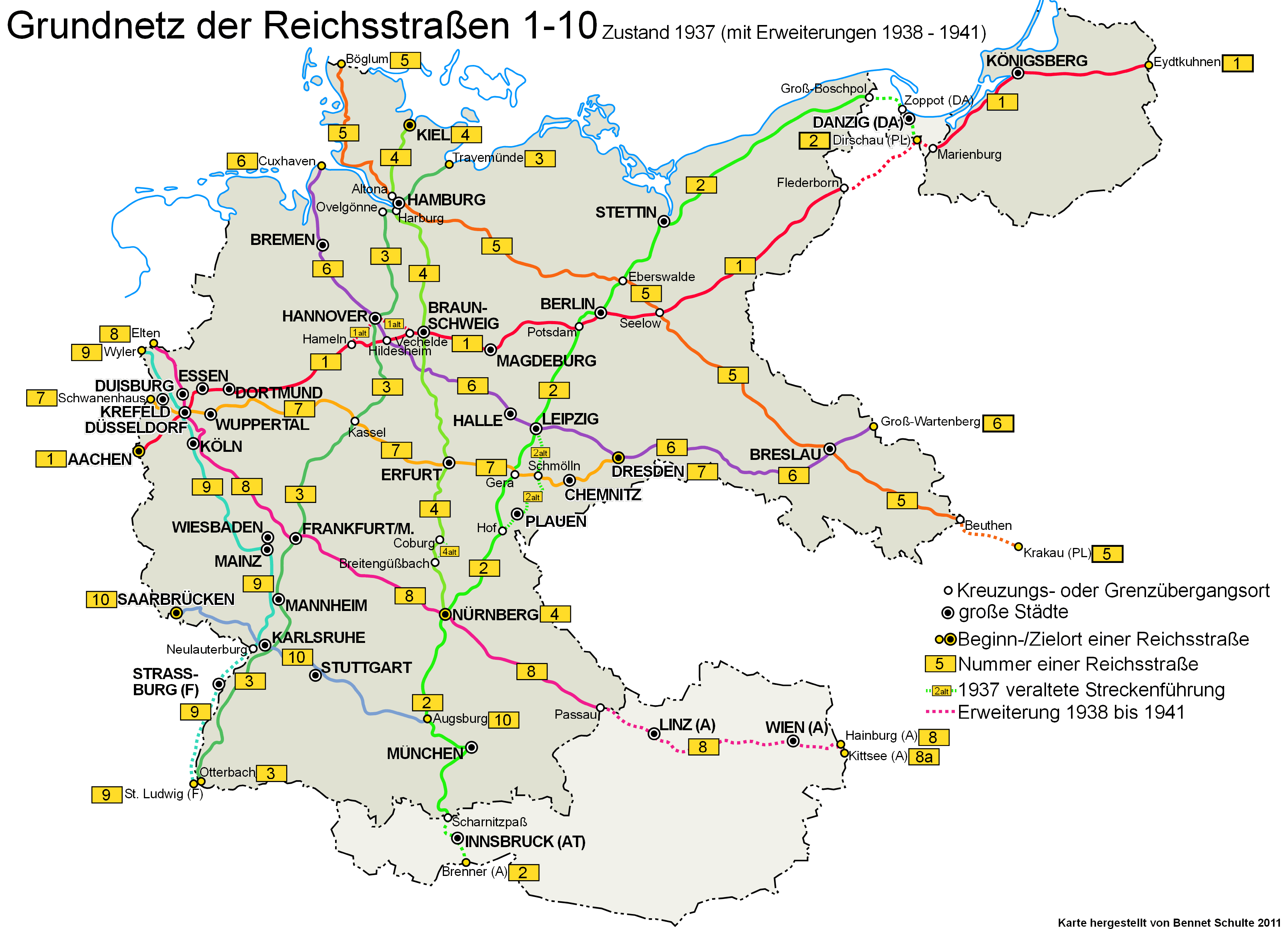
English: Basic network of the Reichsstrassen (number 1 to 10) in 1937 including addition 1938-1941
Deutsch: Grundnetz der Reichsstraßen mit den Nummern 1 bis 10. Dargestellt wird der Zustand von 1937 mit Erweiterungen 1938 bis 1941. |
||
| Datum/Tiet | |||
| Born | Egen Wark | ||
| Autor | Bennet Schulte | ||
| Lizenz/Verlööv (Disse Datei annerwegens bruken) |
Disse Datei is freegeven ünner de Creative-Commons-Lizenz NaamDorbi-EgaleWiedergaav 3.0 Düütschland.
 |


Lizenz
- Du dröffst:
- wiedergeven – Kopien maken, an Annere wiedergeven un överdregen
- nee tohoopsetten – dat Wark verännern
- Ünner disse Bedingen:
- Naam nömen – Du musst den Naam von’n Autor oder von’n Afspraakgever in de von em fastleggte Wies nömen (aver nich so, dat dat utsüht, as wenn he di oder dien Gebruuk von dat Wark ünnerstütten deit).
- egaal wiedergeven – Wenn du dit Wark ännerst, afwannelst oder in en eegen Wark inboost, dörffst du dat nie’e Wark, dat dor bi rutkummt, man ünner desülve Afspraak oder een, de so temlich dat sülve is, rutgeven.

|
Ünner de Maatgaven vun de GNU free Lizenz för Dokumentatschoon, Version 1.2 oder en latere Version, rutgeven vun de Free Software Foundation;, dörffst du disse Datei koperen, wiedergeven un/oder ännern; dat gifft keene unverännerlichen Afsneed un keen Ümslagtext vörn oder achtern. Den fullen Text vun den Afspraak is in't Kapitel GNU-Afspraak för friee Dokumentaschion verfögbar. |
Datei-Historie
Klick op de Tiet, dat du de Datei ankieken kannst, so as se do utseeg.
| Datum/Tiet | Duumnagelbild | Grött | Bruker | Kommentoor | |
|---|---|---|---|---|---|
| aktuell | 14:09, 23. Mär 2023 | | 3.348 × 2.416 (720 KB) | Spazzo | Position "Duisburg" and "Krefeld" changed |
| 17:03, 19. Jan. 2011 |  | 3.348 × 2.416 (265 KB) | Exec | -corrected country add for Linz and Wien | |
| 17:00, 19. Jan. 2011 |  | 3.344 × 2.408 (265 KB) | Exec | -corrected country adds -Tonder -> Böglum | |
| 16:48, 19. Jan. 2011 |  | 3.364 × 2.424 (267 KB) | Exec | -corrected spelling | |
| 16:46, 19. Jan. 2011 |  | 3.344 × 2.408 (267 KB) | Exec | -legend item added | |
| 16:38, 19. Jan. 2011 |  | 3.348 × 2.416 (265 KB) | Exec | {{Information |Description={{en|1=Basic network of the Reichsstrassen number 1 to 10 in 1937 including addition 1938-1941}} {{de|1=Grundnetz der Reichsstraßen mit dem Nummer 1 bis 10. Es wird der Zustand 1937 gezeigt mit Erweiterungen 1938 bis 1941.}} |S |
Dateibruuk
Disse Sied bruukt dit Bild:
Allmeen Datei-Bruuk
Disse annern Wikis bruukt disse Datei:
- Bruuk op als.wikipedia.org
- Bruuk op de.wikipedia.org
- Bruuk op en.wikipedia.org
- Bruuk op www.wikidata.org